Swaraj Dweep or Havelock Island, is one of the
most beautiful islands in the entire Andaman and Nicobar archipelago.
Situated approximately 40 kilometers northeast of Port
Blair, Havelock is 92 Sq. KM in area, spanning 18 km in length and 8 km in
width.
Havelock is famous for some of the best white
sand beaches in the world. The color of the water in and around Havelock is
simply breathtaking. With myriad hues of aquamarine, teal, and turquoise
blending together, the water here is so beautiful it's really hard to describe
the color in one particular shade. In my opinion, the unique shades of the Andaman
sea in Havelock, should have its own name of Havelock Green.
 |
| Andaman Sea at Havelock |
How to Reach Havelock
Ferries provide a very easy connectivity from
Port Blair to Havelock. We visited Havelock on April 2022, and after the
lifting of COVID restrictions, we saw a number of private operators running
their ferries in the Port Blair-Havelock route. Makruzz, Green Ocean, Nautika
are some of them.
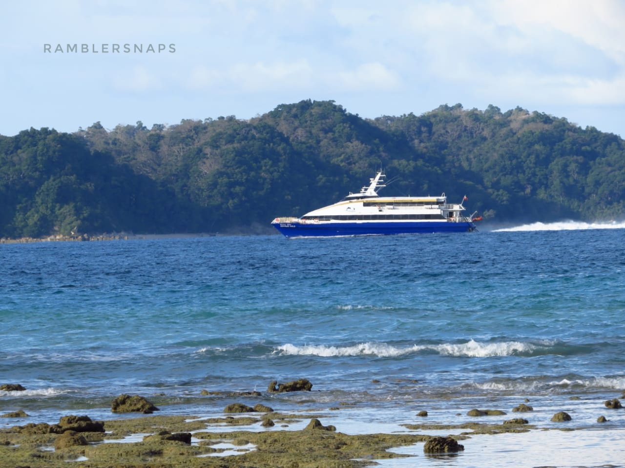 |
| Makruzz Gold |
We availed the Makruzz Gold, and it was really
good. We booked the deluxe class, which is on the upper deck. We booked the 2*2
seats, and had great visibility from the large windows. Even though you can't
go outside at the deck, the visibility from the large windows from your seat is
good enough for capturing snaps or recording a video. In my opinion do not book
the royal class which is a cabin of 8, but only 2 seats among them have window
access. The premium class on the lower deck, looked a bit busy, and unless you
are restrained with your budget, I would recommend to avoid it.
All the private operators now operate from Haddo
Jetty, which is the most developed port of Port Blair. Please note previously
they were operating from Phoenix Bay jetty, however recently this has changed.
In the Haddo Jetty, you will be asked to show
your RT-PCR test report or double vaccination certificate, so please keep them
handy.
The Journey towards Havelock
The ferry time
from Port Blair to Havelock was around 1 hour and 15 minutes for us. The
sea was pretty calm when we travelled, hence we reached 10 minutes before time.
The journey through the deep blue ocean was very beautiful, and we didn't
experience any turbulence. Most of the passengers also looked very comfortable,
and the stories of sea-sickness didn't really look applicable at least when the
sea is calm. The Makruzz leaves Port Blair, and sails past the north bay
island. You get a great view of the dense palm tree plantation of the north bay
island and the lighthouse in this trip.
 |
| View from Makruzz - North Bay Lighthouse |
The color of water in the deep sea is blue, however as you approach Havelock, due to the presence of corals underneath, and due to the shallowness of water, the colors get changed dramatically. You can see those beautiful aquamarine shades, as your vessel approaches havelock jetty.
The embarking and disembarking from the vessel is
hassle free. After collecting our luggage and taking few photos of the jetty,
we came out of the jetty area. Numerous auto rickshaw and car drivers will be
waiting for you, when the vessel reaches
Havelock, so no advance booking of transport is necessary. Drop to any hotel
near Vijaynagar or Govindanagar beach, costs you 200 rupees from the jetty, it's
a fixed price in Havelock, so don't worry about bargaining, just take a cab and
reach your hotel. It will take 10 to 15 minutes to reach your hotel from the
jetty, depending on the location.
 |
| View From Havelock Jetty |
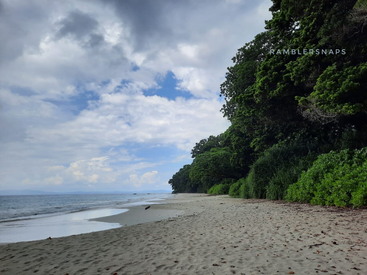
Beaches of Havelock - Kalapatthar Beach
Whenever you are visiting any of the Andaman
islands, please keep a note of the high and low tide timings. This plays a huge
role in your travel experience. The beauty of the beaches is very much
dependent on this, so please keep this handy.
Please note apart from Radhanagar beach, which
always receives sea waves, beaches like Kalapatthar and Vijaynagar, becomes dry
in low tide, and hence should be avoided during this time.
Immediately after checking in our hotel, and
after a quick bath, we started for Kalapatthar beach. The high tide time for
that day was around 11.30 a.m. When we reached the beach, it was 1.30 p.m. and
the timing was just perfect for visiting the beach.
The route from Dolphin resort to Kalapatthar
beach is around 5 km, through the Palm and Beetle nut plantations which are in
abundance in Havelock. It takes around 15 minutes to reach Kalapatthar beach.
The amenities setup by the tourism department is pretty decent. They have made
few beach huts and sea beds for relaxing in the shades. However when you have
such beautiful water in front of you, you can hardly resist the temptation of
feeling the sand and water beneath your feet.
 |
| View from the beach huts - Kalapatthar Beach |
Kalapatthar is an east facing beach, so 1 p.m. that day, was the perfect time for visiting the beach. The sunlight was coming just at the perfect angle from the back, to make the water look even more prettier. The high tide had receded an hour back giving back a broad section of white sand beach, which was just perfect for walking. We found the color of the water in Kalapatthar beach as most beautiful, in the entire Andamans. Its a gorgeous shade of bright teal. The white sand beach against that teal color looked mesmerizing.
 |
| Color of Ocean - Kalapatthar Beach |
From the busy section of the beach we walked around a kilometer on the right hand side, and found out some seclusion. We just setup our camera on the beach for shooting videos, and laid back on the beach. The sweet breeze coming from the sea was so relaxing, you will hardly realize the heat. The thick mangrove forest along the Kalapatthar beach is extremely pretty and we found a shade underneath that foliage, sat on the soft white sand, and just relaxed.
The ambience was therapeutic, as the gentle
waves, sweet breeze and complete seclusion will provide you one of the most
peaceful experiences you can ever have beside the ocean.
 |
| Boulders at Kalapatthar Beach |
Kalapatthar gets its name from some big black boulders on the beach, which probably are some outcrop of the hills in Havelock. The rocks look really pretty, and is a favorite instagrammable location among the travelers. There were some exotic looking driftwood on the beach, and really looked picturesque.
 |
| Surreal Beauty of Kalapatthar beach |
The coconuts in the Andamans are really supreme. The Nicobari Queen Coconut, which is orangish in color, have the sweetest of water I've ever tasted. So do not miss on that.
Kalapatthar beach has some stalls setup by locals
for food and souvenirs, so if you want, you can buy something as memories.
Radhanagar Beach - The king of all Beaches
Havelock rose to prominence as a world class
destination because of Radhanagar beach. It's a dream beach, within any island.
The beach is vast almost 3 km in length, and extremely broad, with soft powdery
sand to walk on. However the most gorgeous part of the beach which we felt, is
its location. It's on the western side of the island, which is actually a
reserve forest. There are very few public beaches in earth which actually is
inside a thick jungle, and Radhanagar definitely is one of them. The tall Sea
Mohua trees, that fringe the forest looks absolutely thrilling against the
white sands of Radhanagar.
 |
| Forested and Secluded Radhanagar Beach |
After spending couple of hours in Kalapatthar we started
around 3.30 pm towards Radhanagar beach. Radhanagar beach is almost 18 km from
Kalapatthar beach, so it will take around 35 minutes time to reach there. The
last part of the journey is through a forested area which looks very beautiful.
After reaching the beach, we as usual left the
busy area to find some seclusion. This time we walked on the left hand side, towards
the hill, which kind of guards Radhanagar beach from the rest of the island.
The walk through the soft sand, with the thick foliage behind was absolutely
pristine. The aroma of the foliage mixed with the sweet smell of the sea breeze
created magic. We walked through the beach, sometime waded through the gentle
waves, and enjoyed the ambience. Radhanagar beach is perfect for sea bathing
and swimming so we saw some people enjoying the water.
 |
| The white sands of Radhanagar |
After exploring the left side of the beach, we started to come back to the right hand side of the beach, from where you can see the famous sunset of Radhanagar. When we arrived at Radhanagar, around 3.30 pm there were very few people in the beach, but by the time we returned to the main busy section, it was almost 4.40 pm and people have started to gather to watch the sunset. In the main beach section there is a beautiful wooden watchtower constructed by forest department, which provides a bird's eye view of the entire beach. We enjoyed the view of the beach from the watchtower, it was really beautiful.
 |
| View of Radhanagar Beach from Watchtower |
After coming down from the watchtower, we ditched the crowd once again, and started walking towards the right hand side, to find a secluded spot to enjoy the silence, which thankfully you can find easily in Havelock. The right side of the beach seemed even more picturesque with even thicker forest cover, so we decided, that we will come back to this side next morning during the high tide. We sat on the soft sand, and waited for the sunset.
 |
| Sunset at Radhanagar Beach |
Unfortunately there were some clouds on the western part of the sky, so the sunset was not as beautiful, as we thought of, but that happens with nature. However the ambience of a golden sky flanked by clouds and the gentle golden waves of Radhanagar beach was beautiful nevertheless.
Since the beach is within a forest, the
authorities do not allow people to stay at the beach beyond the sunset, so we
left the beach and returned back to Dolphin Resort, which was our accommodation
for the 3 days we spent in Havelock.
Food Options in Havelock
That day after returning to Dolphin resort, we
had our dinner at the hotel restaurant, It's a pretty decent restaurant with the
option of North and South Indian food along with Chinese. We had couple of more
meals at this restaurant and will definitely recommend this.
Apart from the restaurant inside Dolphin resort,
we also had a lunch next day at Full Moon Cafe. It was walkable distance from
Dolphin resort. We really liked the food over there, we had fish and chips and
also a Bengali style paturi (fish wrapped in banana leaf and steamed), both the
dishes were awesome.

A walk on the Kalapatthar Beach
For a better fine dining option, you may visit the Bonova restaurant at Sea
Shell, Havelock. We had a dinner at their restaurant, and it was worth the
price, with beautiful ambience and music.
VijayNagar Beach
Dolphin Resort, has their own private beach
access towards the Vijaynagar beach. In fact in the Vijaynagar beach area, it
is very difficult to find a public access to the beach, as most of the Vijaynagar beach
are part of the resorts setup in the locality. This provides a very private
experience of enjoying the beach for the hotel guests, which is otherwise very
rare, in mainland India.
 |
| Palm Fringed Vijaynagar Beach |
Dolphin resort is a vast resort sprawling over a
huge land, and it has a lovely access to the beautiful Vijaynagar beach.
Vijaynagar beach is a bit rocky, however looks beautiful in the high tide, when
the rocks are hidden underneath the turquoise green water. The beauty of
Vijaynagar beach is in its palm fringed coastline. neither Kalapatthar nor
Radhanagar has this palm fringed coastline, so Vijaynagar beach has its own
beauty in this regard.
A revisit to Neil's Cove during high tide
Next day at around 11 a.m. we once again visited
Radhanagar beach, to enjoy the high tide and the color of Andaman sea during
the high tide. While Radhanagar is famous for sunset, we liked the beach
more, during the day time, as the beach is almost empty, and the sound of waves
crushing against the shore really created a perfect symphony. As planned last
afternoon, this time we decided to explore the right hand side of the beach, which
is longer than the left hand side. The crescent shaped shoreline with thick forest
cover looked absolutely beautiful. It's more of a cove on the right side, and
is also known as Neil's Cove.
 |
| Pristine Neil's Cove at Havelock |
We crossed the entry of the famous Barefoot Resort, and continued to walk through the soft sands. After walking for another 500 meters we found a driftwood on the beach, it looked so scenic on the empty beach, that we decided to seat there, and take some photos with it.
 |
| Incredibly beautiful Neil's Cove |
Weather in Andaman Island is unpredictable. Here bright sunny days often gets short spells of a splashing shower. We were relaxing at the Neil's cove, suddenly we saw some dark clouds hovering in the distance over the ocean. It was raining heavily on the ocean, but we were still sitting dry, just a few hundred meters away from it and were enjoying the unexpected rain.
 |
| Rain on the Ocean - At Radhanagar |
Slowly we saw the clouds sailing inside the island, and within a few minutes it started drizzling on the beach too. We took shelter inside the deep forest which is just beside the beach. Those, who were on the beach, also ran for cover. When the drizzle stopped and we once again came out on the beach, we experienced something magical. The beach was completely empty, there were no one except the two of us on the vast white sands of Radhanagar. the fragrance of the rain drenched forest and the sounds of high tide was a magical combination on that complete isolation. It felt like we have been cast away on a desolate island for days, where in front of us there's nothing except green sea and white sand. It was simply an amazing moment.
 |
| Cast Away - in Havelock |
Dolphin Resort and Other
Dolphin resort maintained by Aniidco is one of
the better options to stay at Havelock. We stayed at the deluxe category rooms,
which is extremely spacious, with a big balcony from where you can have a nice
view of the ocean. There are executive rooms and VIP cottages also. VIP
cottages have the best location, and newly built, however they come at a premium
price of 15K + Tax per day.
There are some very good resorts which are within
walkable distance from Dolphin resort, such as Coral Reef Resort, Tilar Siro by
CGH earth and Sandy Waves Resort. All these resort looked beautiful from
outside and they also have a private beach.
 |
| View of Radhanagar Beach - Near the Barefoot Resort |
However the Barefoot Resort has the most beautiful location within Havelock. It is situated on Radhanagar beach, so one can visit the beach any time during the day, if staying in the resort. The resort's location within the forest provides a beautiful experience. In our opinion if budget permits, one should stay a night at Barefoot, for truly experiencing the mesmerizing beauty of Havelock.


