AdUnit3

Sunday, November 11, 2018

A Guide to South Goa Beaches


When it comes to comparing South Goa and North Goa beaches, they are completely different in their characters. While South Goa beaches are cleaner, pristine, with soft powdery white sand perfectly suited for laid back family travellers, North goa’s more happening beachfronts allure the young crowds looking for nightlife and adventure sports but lacks in sand quality and cleanliness.
The sunset at Utorda Beach


So it doesn’t make any sense to compare north goa beaches with the south goa ones. In this write up I will be comparing the best beaches in South Goa, so that you can select the beach best suited to your taste.
Even though they are pretty similar, but there is subtle difference between them, which might become a deciding factor for you to choose your base in Goa.
I visited most of the South Goa beaches starting from Arossim in north to Palolem down south this November. The season had just started, and the beaches with the newly built shacks were getting ready to invite the tourists for the upcoming peak winter season.


Arossim – One of the northernmost beaches in South Goa. Very near to the airport. It hardly takes 20 minutes to reach Arossim from Airport. The beach is clean with powdery white sand typical of south goa, and has a considerable presence of coconut trees on the shore, making it picture perfect. There is a hillock on the northern side of the beach, so in total it’s a pretty scenic one. The newly refurbished ITC Grand Goa is at Arossim Beach.
Palm Trees & Beach - Near ITC Grand Arossim

White Sands - Arossim Beach


Utorda – Another extremely clean beach. In my opinion probably the cleanest beach in Goa. The beach has some very good 5 star resorts with direct sea beach access. It has some good shacks and a sea side restaurant in Zeebop. The locality is very peaceful and perfect for peace loving family crowd. The sand and water quality is similar with Arossim, however the hill in northern side is further away, and also there’s less coconut tree on the beach, so it’s not as picture perfect as Arossim.
The white Sands of Utorda Beach

Cleanest Beach in South Goa - Utorda


Betalbatim – Similar to Utorda, and have good restaurants in the locality in Martins corner and Fish Ka. However doesn’t have the same quality of 5 star  resorts like Utorda, and looks flat in both northern and southern side due to lack of any hillocks


Colva – The busiest beach in South Goa, and hence lacks a bit on the cleanliness quotient. However with its long stretch of coconut trees along the shore, looks pretty scenic. Not the best suitable one, if you love serenity. Sand quality of Colva and Betalbatim are similar, but not as good as Utorda/Arossim.


Benaulim – Probably the best beach for sea bathing, in South Goa. The waves here are pretty gentle, and the quality of water is extremely good. The quintessential aquamarine color of the sea is pretty prominent here, because of water quality. It also has good shacks. Both Colva and Benaulim are very long beach, which gives people a very good opportunity to have a stroll along the shoreline.  The extremely famous Taj exotica is situated in Benaulim.
Best beach for bathing in Goa - Benaulim
Varca – As a beach Varca is similar to Utorda and also has a distant hill on its southern side, which looks picturesque. To me it’s the cleanest beach after Utorda, with soft white sand. The uniqueness about Varca is its casurina trees along the shoreline, instead of the usual coconut trees, which gives varca a distinct look. Lot of high end hotels with direct beach access is present in Varca, so another ideal place for peace loving tourists. The locality around Varca is extremely picturesque with picture perfect bungalows situated amidst huge courtyards.
The clean & serene Varca Beach white sands


Cavelossim/Mobor – Very close to each other but I liked Mobor more than Cavelossim. Mobor possibly has the whitest sand in entire south goa, specially the beach in front of Leela Goa, is extremely broad, and very clean and white. On the southern side there is the same hill, which is distantly visible in Varca, but is much closer in Mobor, and hence gives it a feeling of a beach tucked away on the lap of hills.  
White Sand Mobor Beach with hills on the south


A walk down the mobor beach will take you to the Sal river estuary, so it’s an extremely picturesque place, with a combination of White sand, turquoise water, hill and river. Only problem with Mobor can be it’s a bit isolated so might not suite everybody.
The vast expanse of Mobor Beach
Another problem with Mobor is lack of decent mid-range staying option, as both the properties Leela and Holiday inn are high end and expensive


 Agonda – Probably the most picturesque beach in South Goa, at this moment, situated in a small little cove, and guarded by hills on both side. There are some huge rocks in the sea, which gives Agonda a special look. The sand however is not whitish here, and compared to other south goa beaches, it’s a bit yellowish. The staying options in Agonda beach are decent, but there’s a lack of high end resort, and the approach road to the beach is somewhat difficult to locate. The locality is rural, and not the most picturesque.
The Picturesque Rocky Agonda Beach

Agonda Beach - Guarded by hills on both sides


 Palolem – Once the most picturesque beach with white sand, crescent shaped shoreline, and a thick coconut tree cover, is losing its charm, because of excessive commercialization. It’s a favorite among the day visitors, so remains busy throughout the day. But on the flipside are the heckling adventure sport vendors, who always run after you. The beach might still be extremely beautiful during early morning or late in the evening, but might not be the best place to stay, and can be used as a day visit option.   
Palm trees of Palolem

Turquoise water of Palolem 


Overall south goa is a very peaceful and picturesque place to stay and spend some quality time with your loved ones. Select the beach and the accommodation as per your taste and enjoy!!

Sunday, October 28, 2018

Majestic Malwa


Monsoon is always a good time to visit the central Indian highlands. This is the time of the year when the rolling hills in the region are painted with mossy green and the dark clouds bring the temperature down. This monsoon we decided to visit the Malwa Plateau – the famous highland nestled at the foothills of Vindhya Mountains.

View from Choral Dam
Monsoon Greenery - View from Choral Dam
Malwa is rich in history. It’s the region where the great king Vikramaditya reigned. It’s the birthplace of poet Kalidasa. Later in modern times Malwa rose to prominence once again through the patronage of Rajmata Ahilya Devi, who ruled from Maheshwar near Indore.

We planned for an extended weekend trip of 3 days around Indore covering Choral Dam, Patalpaani waterfall, Omkareswar & Maheshwar.
Choral Dam 

Our trip started with a surprise. Our Jet Airways flight to Indore happened to be their first flight in CCU-IDR route. So we got a grand reception at the boarding gates, we were greeted with chocolates and some beautifully decorated yellow roses, the flowers were really gorgeous. After a couple of hour’s flight when we landed at IDR airport the aircraft was given a salute with water cannons, which were a sight to behold.
We had our car waiting for us at the airport, and drove straight towards Choral Dam & resort which is located near MHOW, around 40 kilometers from Indore.

Local Fishermen at Choral Dam
MHOW cantonment is a treat to watch. It’s a typical squeaky clean cantonment town, with great buildings and history associated with it. We reached Choral resort within an hour. MPTDC has set up a nice sprawling resort by the banks of Choral Dam. The dam has been constructed over the Choral River. During monsoon the lake with dark clouds hovering over the water and wooded hills on the background looked absolutely enticing.

The afternoon was spent with some aimless walk around the lake. Local fishermen were pretty busy looking for their catch on the lake. We saw a lot of them, sailing with their country boat on the vast lake. Boating is also a popular option at Choral. We could see weekend crowd enjoying their ride at the placid waters. A colorful sunset marked the end of our day at Choral.
Sunset at Choral Dam
Experiencing a heritage Railway at PatalPani

The next morning our first destination was Patalpaani waterfall. Our added attraction to visit Patalpaani waterfall was to also see the famous meter gauge train chugging along the Vindhya Mountains. The meter gauge track was an engineering marvel from pre independence era. It connected Indore at Malwa plateau with the plains of Maharashtra at Khandwa, crossing the mighty Vindhyas. The route between Patalpaani and Kalakund is the most scenic section of this route where the track winds its way uphill through the ghat section. As a bonus the passengers also get a glimpse of the mighty Patalpaani waterfall from the train.

During monsoon Patalpaani waterfall was at its full glory. At Patalpaani, Choral River, leaps from a height of 300 meters to form this waterfall, and then meanders its way through a narrow ravine in the woods.
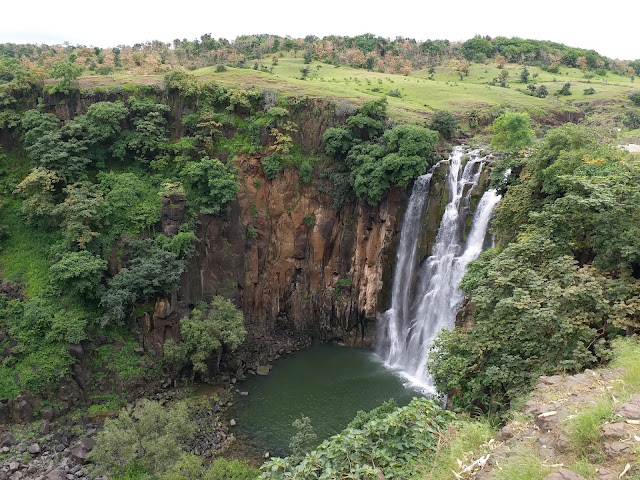
Pataalpani Waterfall at Monsoon
As we were enjoying the waterfall, the MHOW – Sanawad meter gauge passenger also arrived and slowly chugged along the ghats. With the plunge of Patalpaani at one side, and the rustic meter gauge train on the other side, it was the most magical picture one could draw in nature’s canvas.   
Meter Gauge Train Patalpani
Sanawad Passenger at Pataalpani

Omkareswar Jyotirlinga

Soon after the train left we started our journey towards Omkareswar. Omkareswar is a busy pilgrimage town on the banks of river Narmada. The famous Jyotirlinga is situated in an OM shaped island in the middle of Narmada, which can be reached via a hanging bridge on foot. The view of majestic Narmada flanked by Vindhya hills on either side, from that bridge is magical.
Narmada at Omkareswar
The Scenic Omkareswar Jyotirlinga
The temple can also be reached via mechanized boat taken from any of the ghats by the banks of Narmada. The boats in this region are pretty colorful and looked pretty enticing in the middle of clear blue Narmada water. The main temple is centuries old but with the ornate carvings in its wall, still looks as majestic as ever.

It was a Sunday, so the place was brimming with pilgrims all over nearby places. There was a long queue in front of the sanctum sanatorium, and it looked standing on that queue might take few hours. So we decided to take VIP tickets sold at a premium, and visited the deity. Not the ideal way to visit the almighty but when you do not have enough time that was possibly the only way out.
Colorful boats dot the Narmada River
The town itself with holy cows, saffron flags, and omnipresent pilgrims looked totally imbued with faith. There is a magic in these kind of place, as it slowly grows on you, and the same happened with us as well. As we spent more and more time at Omkareswar we started to like the madness of the place. But we had to return back to Choral, which is almost a couple of hours drive, so decided to return back well before the sun down.

Next Day - Towards Maheshwar

The next day our destination was Maheshwar, to experience the majestic fort built on the banks of Narmada by Rajmata Ahilyabai.

From Choral we once again had to cross the Vindhya Mountain, this time through the famous Vanchu point, which provided a mesmerizing view of the rolling hills and the plains below.
Vanchu Point Maheswar
Vindhya Mountain from Vanchu Point Maheswar
Compared to Omkareswar, Maheshwar is a sleepy town, centered on the Ahilyabai Fort.

The fort is grand. The fort along with the ghat in front of it has to be the most scenic waterfront in whole India. It oozes heritage. The fort itself is extremely well maintained, with strong walls, & intricately carved temples & pillars. The grandeur of the palace and the temple inside it reminds people of the golden era of the Holkar dynasty, led by Rajmata Ahilyabai.
Ahilyabai fort from ghat
Ahilyabai Fort as seen from the ghat
Ahileshwar temple dedicated to lord Shiva is the main temple complex inside the fort. It’s still an active temple, used by both the local people and the royal family who lives inside the fort complex. The temple with its intricately carved granite walls, is an epitome of the Maratha architecture.
The Legacy of Maheshwar

The majestic fort, and the beautiful ghat with its well-designed stairs going down to the languid Narmada in front of it, creates a picturesque setting. A boat ride along the Narmada to look at the daily chores on the ghats couldn’t have been missed. The boat ride along Narmada offered us the best lookout points to enjoy the majestic beauty of the Ahilyabai fort. Lots of devotees were taking a holy deep in the sacred waters of Narmada. The chants of the devotees, the cool breeze of Narmada and the grandeur of the mediaeval fort on the backdrop created a surreal effect.
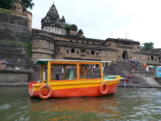
Narmada at Maheshwar
The fort as seen from Narmada at Maheshwar
Maheshwar is also famous for the Maheswari Silk sarees. A lot of families here still earn their livelihood by weaving this piece of art. Most of them are completely handmade and the motifs on the Sarees are inspired by the carvings made on the majestic walls of the Ahileshwar temple and Ahilyabai fort.

The tradition of Saree weaving was patronized by Rajmata Ahilyabai, which helped Maheshwar become one of the famous seats for silk sarees in India.

We visited one such weaver’s house and bought us a handmade silk cotton Saree as a memory of visiting this rich historic place. 

Temples of Maheshwar
Temple Carvings Maheswar - which inspires Maheswari Weavers 
We had our flight to Kolkata from Indore that afternoon, so even though we wanted to stay a few hours more, and enjoy a Sandhyarati on the banks of Narmada, we had to give that a miss. So we started our journey back towards home, leaving behind the rich legacy of Malwa. This region with its great blend of natural beauty and rich history, is certainly an important place in our ‘Incredible India’.    

Monday, June 4, 2018

Bharmour - The Abode of Lord Manimahesh


Beauty of  Pir Panjal at Bharmour
Bharmour or Brahmapur was the erstwhile capital of the Chamba kingdom, before it was shifted to Chamba. The town now is the home of Gaddi’s – the nomadic shepherds of the Himalayas. Gaddis driving their herd of sheeps and goats are a common sight in the streets around Bharmour.
We visited Bharmour during the summer of 2018. The road to Bharmour from Chamba is extremely scenic and exciting. The road winds its way alongside the river Ravi or Iravati. It passes though beautiful villages of Chamba which are situated on the banks of Ravi.
Entering Bharmour
We drove till Kharamukh, a small village around 40 km from Chamba, it is where we left the mountain river, and then started climbing the lofty hills of lower Pir Panjal.

The road from Kharamukh to Bharmour is quite narrow, and as we gain altitude, they started loosing vegetation. On one side of the road is a deep ravine, through which Budhil river (originating from the Pir Panjals) flows like a silvery ribbon.
As we drove closer to Bharmour, the snow laden mountains of Pir Panjal started appearing, including a distant view of the famous Manimahesh Kailash peak. Within 2.5 hours we reached Bharmour market. We had our reservation at HPTDC Hotel Gaurikund, which is situated at the Bahrmour helipad – the highest point in Bharmour.
HPTDC Hotel Gaurikund Bharmour
From market a very steep and narrow road lead us to the helipad, the road is so steep, even the experienced local drivers also find it difficult to negotiate the switchbacks.The helipad gives a panoramic view of the lofty hills that surround Bharmour. Even in mid summer, most of the hills had some amount of snow at the top, which looked enticing.
View From Bharmour Helipad

HPTDCs Hotel Gaurikund is pretty nice. The hotel only has 6 rooms. It’s a 3 storied building with the second floor having the Deluxe and Super Deluxe rooms.  We stayed in the deluxe room, which was value for money @1800 per night.The room was big enough with a clear view of the snow peaks, it had a clean bathroom. The staffs are extremely helpful. The food in the hotel is also extremely homely, a rarity when we are travelling.
We had a sumptuous lunch with home-style chicken curry and mixed vegetables.
On the afternoon we visited the famous Chaurasi temple complex, which is a 5 minutes walk down from Hotel GauriKund.

Temple Dedicated to Lord ManiMahesh at Chaurasi temple complex
The famous Chaurasi temple, situated at the centre of the town, represents the rich history and culture of Bharmour. Dated back to 7th century this temple complex has 84 temples dedicated to various gods and goddesses, and hence is named Chaurasi. The main deity here is Lord Manimahesh, who has the biggest temple dedicated to him. The temples are built in typical Pahari style with one main shikhar and a wooden umbrella type crown on top of the stone structure.
The temple complex is an oasis of peace in the town of Bharmour. The temple complex not only serves as a place for rituals, but also serves as a place for community building, it’s the place where people of Bharmour come down, meet each other and discuss their day to day life and culture. It’s the neucleus of Bharmour.
The temple complex is squeaky clean, which certainly adds to the scenic appeal of the place. With lofty snowy mountains on the backdrop the temple complex is definitely the prime attraction in Bharmour.
Our next destination was the Bharmani Mata temple.

Thick Deodar - Bharmani Mata Temple
Bharmour was the abode of Bharmani Mata, and hence the name of the town. According to the legend, when Lord Manimahesh wanted to make Bharmour his abode, the goddess graciously agreed to shift her abode to the upper hills. In return she asked Lord Shiva for a boon- that all his followers who are going on the Manimahesh Yatra should first visit her and take a dip in the pool for their yatra to be valid . This custom is still followed by the pilgrims.
Situated 6 km. uphill and almost 2000 feet above the main town, Bharmani Mata temple overlooks the town and provides some stunning views of the snow clad Pir Panjal range.
We took a cab from the market, to reach the temple. The road to Bharmani Mata temple is extremely treacherous. It’s a narrow and dirt track that climbs uphill like crazy.
Main Temple of Mata Bharmani
The road goes past famous apple orchards of Bharmour around the Malkote village - a gaddi hamlet situated on the higher slopes of the mountain. After crossing Malkote it climbs a further 2 km to reach the ridge where Bharmani Mata temple is located. Since it’s situated on a ridge, the 360 degree view of the surrounding Pir panjal range from the temple is mesmerizing. With the backdrop of thick deodar forest, the temple really looked like the custodian of Bharmour’s rich history and tradition.
Bugyal at Bharmani Mata
The temple complex has the famous Bharmani Kund, where pilgrims take a holi dip, before venturing to the Manimahesh Yatra. The deity of Bharmani Mata is simple, with a divine aura in her eyes. A weeklong langar seva was going on  when we visited the temple. The friendly people of Bharmour didn’t let us go, without having the food at the langar. The Pahari style mixed dal and vegetable curry was delicious, and it tasted even better because of the love and passion with which it was served.
The vistas around the temple was so beautiful that one can spend hours at the top. Pir panjal snow peaks could be visible all around us. The mountain top was actually a green bugyal with domestic horses, grazing on it.
There is another trekking route of 2.5 km that goes down straight from the hilltop to Bharmour Helipad. The vistas on that route is also surreal. So we decided to leave the cab, and started our way back downhill through the trek route. The trek route actually goes down through the Malkote village, which gave us a great opportunity to witness the intricately carved wooden village homes, and the lifestyle of the villagers. Each family boasts of quite a few numbers of Cow, goat and sheep. The wool and milk that they generate from these animals are the main source of their income, along with the apples from the orchards.
The people of the village are so friendly that some of them wanted us to visit their home, and have a tea with us when we were passing through the village. We would have loved to do that, but since it was already late, we wanted to reach our hotel before it gets completely dark, so we had to politely turn down the offer. When we reached our hotel, it was almost dark. It was a long day for us with full of activity. So we had our dinner early and huddled under the quilt for a warm sleep.
Malkote Village Bharmour
The next day, our plan was to visit Kugti Village. Kugti almost 25 km away from Bharmour is the last inhabited village of the Gaddis. The landscape after Kugti is extremely rugged with lofty mountains that rise upto Kugti pass , which is more than 5000 meter high, and separates Chamba from Lahaul.
Pir Panjal near Hadsar
We set out early enough by 8 a.m. It was a sunny day with clear sky, which made the vistas around us even brighter. The road to Kugti goes till Hadsar, the last motor able stop, on the Manimahesh Yatra route. Then an unmetalled road goes down till Dharol, which is a further 7 km from Hadsar. The road from Hadsar to Dharol runs along the Budhil river. After Dharol, it’s another soft trek of 3 km to reach Kugti.
The road from Bharmour to Hadsar is an uphill climb, with Budhil river flowing down the gorge below. The vistas were spectacular, as more and more snow laden mountains started giving us company. We reached Hadsar within 30 minutes. From Hadsar one trek route goes uphill towards the Manimahesh peak. We could see that trek route climbing its way up through thick deodar forest. The route goes alongside a mountain stream named Manimahesh Ganga, which originated from the Manimahesh Kailash peak and meets with Budhil River at Hadsar.
We drove further, crossed Hadsar, and took the unmettaled road that goes to Dharol. However a bad news was waiting for us in the next bend. A landslide which had happened early morning had completely blocked the road. We saw a part of the mountain, which had completely come down to the road. From the magnitude of the slide it looked like the debris couldn’t be removed within a short time, and might take almost a day. We enquired with the local, and they also agreed in unison. More over, some stones were still falling from the mountains, so until it stops completely,  the PwD workers won’t be starting their work to clear the debris.


Manimahesh Ganga at Hadsar
It was a real heart break for us. The road to Kugti looked absolutely enticing, with languid Budhil river on one side and thick deodar forest in the other side. We knew some spectacular vistas were waiting for us in Kugti, but we had to abort our plan. We went down to the Budhil river, enjoyed the icy cold water, took a few snaps and decided to return.

Even though we couldn’t visit Kugti, Bharmour with its natural beauty and friendly people had already won our heart .
The evening was spent on the Chaurasi temple, and the Sandhyarati with the chants and the chimes of the bells made a perfect end note to our soujourn at Bharmour.